 I took my first ever chopper ride up to near the caldera of Mauna Loa. Here we sampled from several plots to weigh lithics and pyroclastic material ejected during previous eruptions. We were at approx 4000 meters and the work was tough going at such high altitudes.
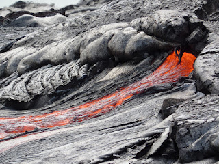
 A couple of days later we undertook a gruelling trek across old lava to reach the hot new stuff. It was well worth the toil as I saw lava for the first time. We witnessed a few breakouts from the lava tubes as the lava made its way to the Pacific Ocean from the East Rift Zone. A huge plume is formed where the hot lava meets the cool ocean.
After giving oursleves a day to recover we then trecked out to the Pali (Hawaiian for cliff) to retrieve GPS receivers. These receivers are far larger and more accurate than the average hand held devices that most people are used to. They are accurate to within 1 cm. The receivers are used to measure any movement of material. The old lava is slowly spreading from the Pali towards the ocean but 'rapid' movements can occur due to seismic and volcanic events.

 images courtesy of USGS